
 Veteran-Owned · Gadsden, Alabama
Precision From Above
Aerial thermal imaging, construction progress imagery and LiDAR data capture for the companies that build, power and maintain Alabama, Georgia, Tennessee and Mississippi.
Aerial Data That Drives Decisions
Enterprise drones and radiometric thermal cameras, flown by a veteran with 14 years in aviation.
Roof Imaging & Documentation
Thermal and close-up visual imagery of commercial and residential roofs, delivered to your roofer, adjuster or licensed professional.
Learn moreSolar Thermal Imaging
Radiometric thermal and visual imagery of every row on utility and commercial solar sites, organized by block and row.
Learn moreElectrical & Utility Scans
Thermal scans of transformers, inverters, poles and lines that flag hot connections before they fail.
Learn moreConstruction Progress
Scheduled aerial photos, video and site overview imagery that show how your job is changing.
Learn moreLiDAR Data Capture
LiDAR data captured for licensed surveyors and engineers to process.
Learn moreInsurance & Restoration
High-resolution roof and structure documentation for faster, safer claims with no ladders on the roof.
Learn more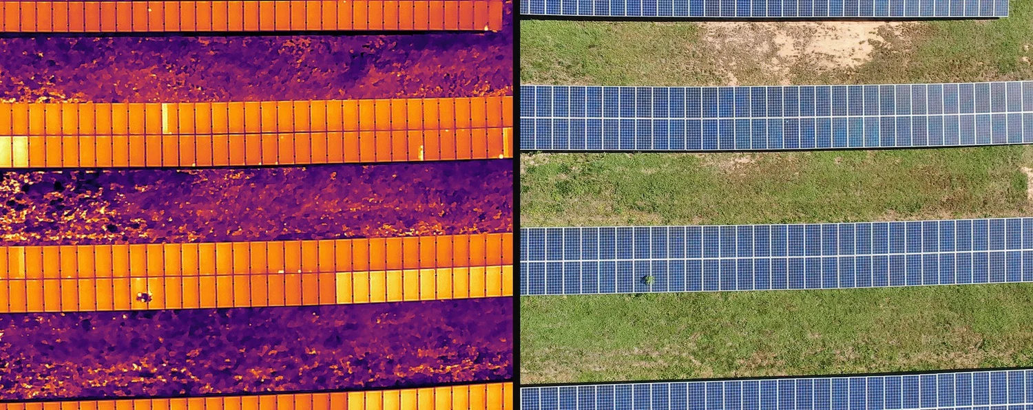
See What the Naked Eye Misses
A radiometric thermal camera measures temperature in every pixel. Paired with a matching visual image, that turns a hidden problem into a documented, located finding your crew can act on.
This solar block looks normal in visible light. In thermal, two overheating modules and a full hot substring stand out immediately.
- Radiometric DJI H20T thermal payload
- Thermal and visual captured on every frame
- Findings located and organized for review
- Branded reports your maintenance team can use
From Flight to Findings
Scope
We confirm the site, goals, deliverables and timing, plus airspace and access.
Fly
Planned, repeatable flights in the right conditions for the job.
Organize
Imagery checked for quality, labeled and organized for delivery.
Deliver
Clear reports and data files in the formats your team already uses.
Built on Military Discipline
Veteran Owned
Founded by a U.S. Army veteran and former crew chief who brings preparation, precision and accountability to every mission.
Enterprise Equipment
DJI Matrice 300 RTK, Zenmuse H20T radiometric thermal and Matrice 4E, not consumer drones.
Data Capture Only
We capture and deliver the imagery. Condition calls and measurements stay with your licensed professionals.
Clear Deliverables
Reports and data built for the people who use them, from plant managers to CAD technicians.
Safety First
FAA Part 107 operations, site-specific planning and respect for your people, equipment and schedule.
Local & Responsive
Based in Gadsden, Alabama and serving clients across Alabama, Georgia, Tennessee and Mississippi.
Animal Search & Deer Recovery
Lost dog, missing horse, loose livestock or a deer you could not find? Our thermal drones search brush, tree lines and pastures from above, day or night, and guide you or animal-control officers straight to the animal. Hunters: we also recover lost deer after the shot.
Ready to See Your Site From Above?
Tell us about your roof, solar site, project or acreage and we will put together a clear scope and quote.
Follow us on social


